Updated September 14, 2021 at 10:51 PM ET
Tropical Depression Nicholas has drenched the Houston metro area as the large storm creeps over southeastern Texas and southwestern Louisiana. The system, which made landfall early Tuesday morning as a hurricane, is expected to drop another 5 to 10 inches of rain on a broad area from the northern Texas coast to the western Florida Panhandle through Thursday.
"Life-threatening flash flooding" is possible, particularly in urban areas, the National Hurricane Center said.
Parts of southern Louisiana could see isolated rain totals of 20 inches, according to the agency.
Nicholas is 15 miles west-northwest of Port Arthur, Texas, moving east-northeast at 6 mph, the hurricane center said in its 10 p.m. CT update. The storm's maximum sustained winds have fallen to 35 mph, but it's the rain and storm surge that forecasters said people should be wary of.
Louisiana gets a dire forecast
Parts of southern Louisiana are still coping with the effects of Hurricane Ida — including tens of thousands of people who remain without power two weeks after that storm hit. Now they find themselves being inundated by Nicholas.
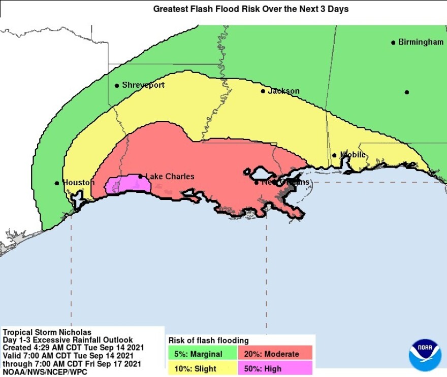
Six to 10 inches of rain are expected to fall on a majority of the Louisiana coast in a warning area extending from west of Lake Charles beyond New Orleans.

The National Weather Service says a huge chunk of the coast and inland areas from Texas to Mississippi face a moderate risk of flash flooding, meaning those floods are at least 20% likely of occurring. Parts of the warning zone extend more than 100 miles inland, covering more than half of Louisiana.
"It is possible that Nicholas could stall over southwestern or central Louisiana," the hurricane center said Tuesday.
The system is still projecting tropical storm-force winds 140 miles from its center — but the majority of those winds are southeast of its center, out over the Gulf of Mexico.
Nicholas will likely become a tropical depression by Tuesday night, with further weakening expected on Wednesday.
Nicholas knocks over part of a gas station
Even before Nicholas made landfall, the hurricane's winds toppled the metal canopy of a gas station in Matagorda, Texas, southwest of Houston.
WHOA! 😬😳 A canopy at a landmark gas station in Matagorda, TX, went down for the count, thanks to #HurricaneNicholas' high winds. We have our eyes on the damage here: https://t.co/NOdHCXwZoZ pic.twitter.com/RtSi0kzTpX
— ABC13 Houston (@abc13houston) September 14, 2021
As of early Tuesday afternoon, more than 342,200 utility accounts are now without power in Texas, according to the tracking site PowerOutage.us. Louisiana has more than 99,000 outages, particularly in the southeast portion of the state — although some of those date to Hurricane Ida.
A clip of video footage captured the moment when Nicholas knocked out power in Lake Jackson, east of Matagorda.
💡There go the lights!🕯️
— WeatherNation (@WeatherNation) September 14, 2021
Watch Hurricane #Nicholas knock out the electricity in Lake Jackson last night. This is in Brazoria County where 75% of customers are without power this morning. #TXwx pic.twitter.com/nqw9mXH6fh
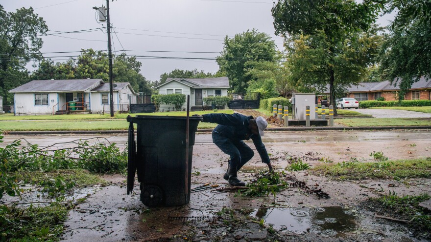
Other damage ranges from numerous downed power lines and uprooted large oak trees to flooded roads and damaged piers.
Despite the damages, and the disruptions due to canceled classes and travel plans, many in Houston are breathing a sigh of relief.
Because a large portion of Nicholas' heaviest rains stayed offshore, "We were able to dodge a lot of the potential for river flooding," hydrologist Katie Landry-Guyton of the National Weather Service Houston/Galveston office said on Tuesday.
"We were blessed last night," Mayor Sylvester Turner said on Tuesday, according to Houston Public Media. "I'm not going to say lucky. The lord just smiled on the city of Houston last night. We needed a break."
Slow movement will bring more flooding
Nicholas will likely slow down as it heads toward Louisiana — a situation that brings to mind the slow-moving Hurricane Harvey, which devastated parts of Houston with days of torrential rain in 2017. Nicholas is predicted to cover only a small amount of ground over the next day.
"Even if the winds start to decrease, that's not going to change the impacts," National Hurricane Center Director Ken Graham said in an update on the storm. "You're still going to get that heavy rainfall, the life-threatening rainfall."
As of Tuesday morning, several storm surge and flood warnings were canceled for coastal areas south of Port Bolivar, near Galveston. But a storm surge watch remained in effect from Sabine Pass, along the Texas-Louisiana border, to Cameron, La.
"An eastward turn is expected over Louisiana by Wednesday. Little motion is anticipated on Thursday," the hurricane center said.
Climate change has been linked to the more frequent occurrence of intense hurricanes. In addition to strong winds, many of the most dangerous storms in recent years have brought tremendous amounts of rain – creating new threats to people and infrastructure far inland from the coast.
Copyright 2021 NPR. To see more, visit https://www.npr.org.

